
Problem: Some clients have access to an array of aerial imagery that are georeferenced tagged image file format (.TIFF). This imagery is obtained from various platforms: satellites, fixed wing air craft, or unmanned autonomous vehicles (UAV) also known as drones. Depending on the types of cameras used additional information are collected along the electromagnetic spectrum including thermal and near infra-red imagery. When clients have these types of images they can be used to classify the land cover using either a supervised or unsupervised image classification.
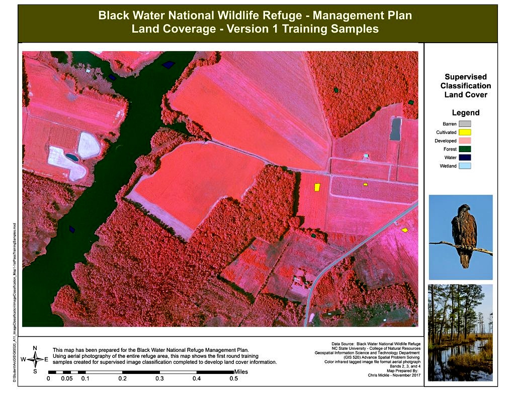
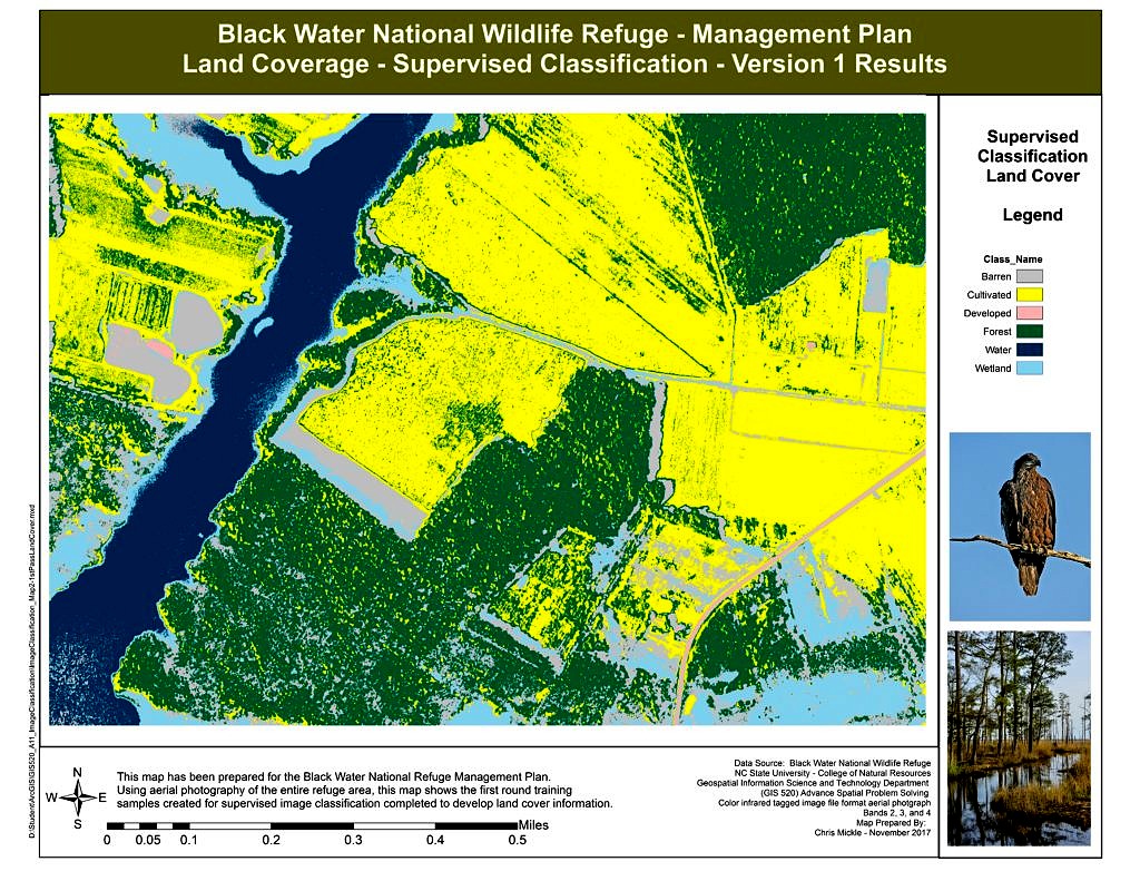
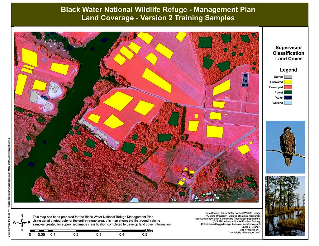
In this example aerial images from the Black Water National Wildlife Refuge have been used to classify six main land cover classes: forest, cultivated fields, barren areas, developed/impervious areas, wetlands and open water. This provides the client, who is a wildlife refuge manager, better understanding of the territory and habitat to assist with overall wildlife refuge management.
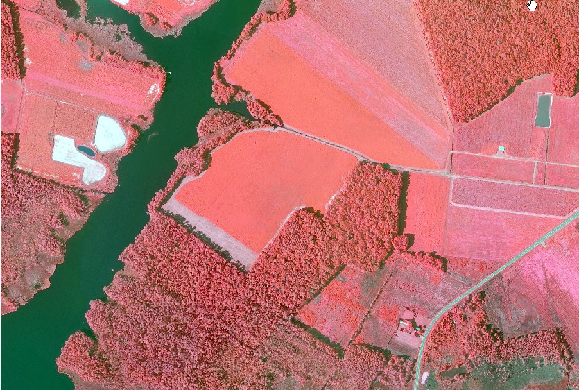
Analysis Procedures: There are different ways in which the aerial image can be classified. Given time constraints, and the extent of the wildlife refuge area, a supervised classification analysis using ArcGIS 10.4.1 software is the optimal solution. The Black Water National Wildlife Refuge has provided an aerial image that is a tagged image file format (TIFF). This format contains several bands containing the spectral signatures of the green, blue, and red (bands 1-3) and near infrared (band 4). This file allows us to enhance the image to utilize the near infrared band which will highlight several electromagnetic spectrum signatures that are different for water, vegetation, soil, barren and developed land. Leveraging these bands allows for optimum supervised classification results as the image is enhanced for the identification of different land covers.
ArcGIS 10.4.1 has an Image Classification toolbar as part of the Spatial Analyst set of tools. This tool bar is used to record training samples, in the form of polygons, covering the different terrain across the wildlife refuge.
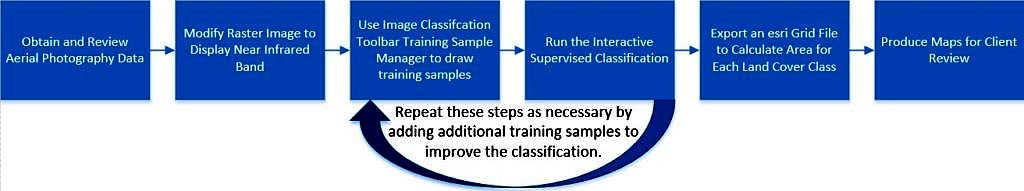
First the image is enhanced by turning it from a True Color Composite image to using the near infrared band with blue and green bands. Once the training sample polygons are drawn for each land cover the Interactive Supervised Classification is run using the training samples to create a temporary raster file with the rest of the image classified. This raster is exported as an esri Grid file so the value attribute table can be reviewed and an area for each land cover is calculated. This process is repeated until an overall classification of all land classes is achieved as adding training samples can improve the overall image classification.
Results:
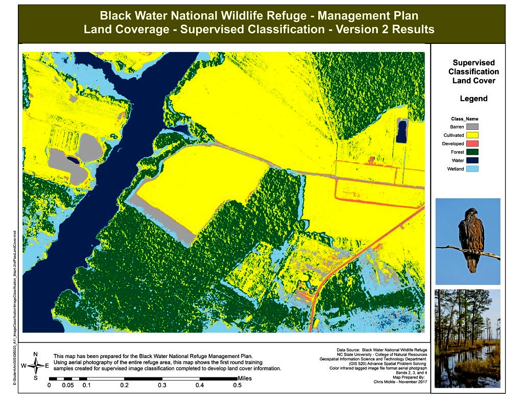
Application & Reflection: Interactive Supervised Classification is an excellent way to quickly and efficiently produce a land cover image classification. Baring you have aerial imagery which includes bands from the electromagnetic spectrum and image enhancement is possible. The application of this approach requires a good sense for drawing training polygons by zooming in close to capture the distinct colors and spectral signatures that are included in each distinct land cover class.
Utilizing spectral signatures and the semi-autonomous process of classifying an image through Interactive Supervised Classification allows for a great amount of work to be completed in a shore amount of time. This method is very useful in finding hidden issues such as water or soil pollution that can be detected by a slightly modified spectral signature of water, or show vegetation that has been weakened and impacted by contamination. This can be done remotely without having anyone enter the contaminated zone thus providing a safer first pass at reviewing contaminated sites. Also, wetland scientists and biologists can use this approach to survey large restoration areas to examine any plantings that were conducted as part of the restoration. A quick view of the spectral signatures of the plants during the growing season will differentiate between healthy vegetation growth versus plants that are suffering and allow for the calculation of overall plant survive-ability.
Problem description: An agency or client seeks to evaluate contamination from an oil in a harbor/marina that has impacted a good portion of shoreline and a nearby estuary.
Data needed: Utilizing a drone with a camera capable of collecting enhanced aerial imagery with both thermal and near infrared bands is used to quickly survey and collect images which also have high visible resolution.
Analysis procedures: Once the images are aggregated into a tiled mosaic covering the entire land area the images are enhanced to display the near infrared band. Areas where the spill occurred in water that show the oil in high concentrations are used as training areas to capture spectral signature and find other areas throughout the marina. Also areas of shoreline that display oil on shore or within the estuary that display oil impacting plant life are used as training samples. The Interactive Supervised Classification can be used to quickly classify oiled water, land and vegetation areas as compared to those un-oiled water, land and vegetation areas to determine the overall impact and areas where restoration activities are imperative. This process would first be implemented as close to the time of the spill and if possible prior to any oil reaching shoreline or impacting any tidal estuaries and marshland. The process is then repeated over a daily to weekly to monthly schedule depending on the overall size of the spill. This schedule will show the impacts to vegetation and shoreline erosion over time.