
Problem: For some GIS work there are repetitive tasks that require the use of tools that do not have a tool on a default esri ArcGIS toolbar. In order to make using ArcGIS more efficient custom tool bars, with tools repeatedly used for a given project, can be made available to your project team members. These tools can help control the flow of work and allow GIS users to work faster and more efficiently on repetitive tasks.
Analysis Procedure: ArcGIS 10.4.1 has a library of tools that are accessible via the customize toolbar panel. Take time to carefully review the steps your GIS staff are undertaking for each project. Where possible, build these steps into an ArcGIS model using model builder. However if there are repetitive tasks that need to be executed manually develop the appropriate tool bar or context menu that streamlines the workflow.
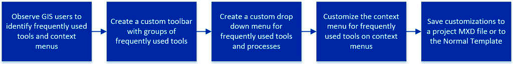

Reviewing and understanding all of the esri ArcGIS toolbars and context menus is a good idea for knowing which tools can be added for a given task. For a given project, determine which tools should be added to a customized tool bar or context menu by observing GIS operators and identifying the repetitive manual tasks done most frequently. Using esri ArcGIS 10.4.1, add these tools to custom toolbars and context menus as appropriate to make them more accessible and easier and efficient to use. The custom toolbars can be saved to an .MXD file for a given project or if they are used on multiple projects add them to the esri ArcGIS 10.4.1 Normal Template.
Application and Reflection: There are several software companies that have developed software to interface with esri ArcGIS for environmental data management and asset management. These software extensions to ArcGIS are accessed to a customized esri ArcGIS toolbar but can bring an entirely new spatial analysis kriging model or other additional functionality. Consultants leverage the ArcGIS framework by building applications that execute custom code designed to solve client problems mapping and data collection problems.
One example of a program leveraging esri ArcGIS technology with a custom menu is from a company called EnterInfo who makes a pavement condition assessment application called eRoadInfo. eRoadInfo’s work process includes capturing 6 high definition images of a roadway and pavement in 6 different directions every twenty feet. These images are spatially referenced so that a pavement inspector can sit in front of a computer and make observations of the pavement without needing to be in the field, creating a safer work environment. There are also autonomous algorithms that can be run to detect certain types of cracking and pavement distress from the imagery. Since the photos are georeferenced if an inspector is capturing assets such as street signs, curbing, trees, etc., they can click on these objects in the image and classify them and the image will position the asset on the GIS map in the 2D plan view.
Another software application that I use for environmental data management is EQuIS (Environmental Quality Information System) developed by EarthSoft. This software application is known for its rigorous data quality checking of data coming from field and laboratory data providers. The data focuses on groundwater, surface water, soil and air environmental sample and analysis data that is spatially rpresetned in a 2D and 3D environment as it has an extensive schema for capturing subsurface geology stratigraphic information. The software has an EQuIS for ArcGIS interface which provides a similar set of tools to use while in esri ArcMap 10.4.1 Some of the tools on the EQuIS for ArcGIS interface toolbar include utilizing third party applications such as Surfer or Rockware to perform 3D Kriging and contouring of contamination plumes that takes into consideration soil and chemical density.
The ability to add custom tools to toolbars in esri ArcGIS provides for many ways to utilize GIS as a framework for a variety of custom applications or integrating third party software within GIS.